Sold2024Ptolemy & Magini, pub. 1620 - Map of India and Surrounding Islands (East Indies)This early map engraving is from Claudius Ptolemaeus (Ptolemy) and Giovanni Antonio Magini's Geografia cio? Descrittione Universale della Terra Partita in due volumni, Nel Primo de' quali si contengonSee Sold Price
Sold2024Ptolemy & Magini, pub. 1620 - Map of the British Isles (England, Scotland, Ireland) / Verso: Map ofThis early map engraving is from Claudius Ptolemaeus (Ptolemy) and Giovanni Antonio Magini's Geografia cio? Descrittione Universale della Terra Partita in due volumni, Nel Primo de' quali si contengonSee Sold Price
Sold2024Ptolemy & Magini, pub. 1620 - Map of Sardinia & SicilyThis early map engraving is from Claudius Ptolemaeus (Ptolemy) and Giovanni Antonio Magini's Geografia cio? Descrittione Universale della Terra Partita in due volumni, Nel Primo de' quali si contengonSee Sold Price
Sold2024Ptolemy & Magini, pub. 1620 - Double Hemisphere Map of the WorldThis early map engraving is from Claudius Ptolemaeus (Ptolemy) and Giovanni Antonio Magini's Geografia cio? Descrittione Universale della Terra Partita in due volumni, Nel Primo de' quali si contengonSee Sold Price
Sold2021Stanford (Pub) 1894 Lot of 9 Maps of Asia East IndiesIncl Celebes, Sumatra, Borneo, Java, Philippines, Stations of Government Officials in the East Indies, Volcanic System of Malaysia, Moluccas, and Sunda Islands. Lithograph Maps Published 1894 by EdwarSee Sold Price
Sold2023World: Ptolemy, pub. 1562 - Map of the Ancient WorldThis early map engraving is Joseph Moleti (Giseppi Moleti [Moletius])'s edition of Claudius Ptolemaeus (Ptolemy)'s Geographia. This is the first Moleti Latin edition of the work and was published by VSee Sold Price
Sold2023Ptolemy, pub. 1562 - Map of ItalyThis early map engraving is Joseph Moleti (Giseppi Moleti [Moletius])'s edition of Claudius Ptolemaeus (Ptolemy)'s Geographia. This is the first Moleti Latin edition of the work and was published by VSee Sold Price
Sold2023Ptolemy, pub. 1562 - Map of Sardinia & SicilyThis early map engraving is Joseph Moleti (Giseppi Moleti [Moletius])'s edition of Claudius Ptolemaeus (Ptolemy)'s Geographia. This is the first Moleti Latin edition of the work and was published by VSee Sold Price
Sold2023Ptolemy, pub. 1562 - Map of Sardinia & SicilyThis early map engraving is Joseph Moleti (Giseppi Moleti [Moletius])'s edition of Claudius Ptolemaeus (Ptolemy)'s Geographia. This is the first Moleti Latin edition of the work and was published by VSee Sold Price
Sold2023Ptolemy, Fries, pub. 1535 - Map of TurkeyThis important historic map is from Geographicae enarrationis libri octo Ex Bilibaldi Pirckeymheri tralatione, fed ad Graeca & prisca exemplaria.... The work was published in 1535 in Lyon after LorenzSee Sold Price
Sold2023Ptolemy, Fries, pub. 1535 - Map of Northern Africa and EgyptThis important historic map is from Geographicae enarrationis libri octo Ex Bilibaldi Pirckeymheri tralatione, fed ad Graeca & prisca exemplaria.... The work was published in 1535 in Lyon after LorenzSee Sold Price
Sold2021Tallis, John (Pub) 1852 Map Falkland Islands, PatagoniaSteel Engraved Map with Original Outline Hand Color Published 1852-56 by John Tallis, London for "The Universal Pronouncing Dictionary" by Thomas Wright. Drawn & Engraved by John Rapkin. Centre fold aSee Sold Price
Sold2021Tallis, John (Pub) 1852 Map. Channel IslandsSteel Engraved Map with Original Outline Hand Color Published 1852-56 by John Tallis, London for "The Universal Pronouncing Dictionary" by Thomas Wright. Drawn & Engraved by John Rapkin. Centre fold aSee Sold Price
Sold2021Tallis, John (Pub) 1852 Map. West India IslandsSteel Engraved Map with Original Outline Hand Color Published 1852-56 by John Tallis, London for "The Universal Pronouncing Dictionary" by Thomas Wright. Drawn & Engraved by John Rapkin. Centre fold aSee Sold Price
Sold2021Tallis, John (Pub) 1852 Map. Polynesia. Pacific IslandsSteel Engraved Map with Original Outline Hand Color Published 1852-56 by John Tallis, London for "The Universal Pronouncing Dictionary" by Thomas Wright. Drawn & Engraved by John Rapkin. Centre fold aSee Sold Price
Sold20211750 Bellin Engraved Map of SumatraA folding map of the island of Sumatra , "Carte de L'Isle De Sumatra…", by Jacque Bellin circa 1750, Paris. Close trimmed at top margin. Fine, measures 15.5 x 10". Reserve: $80.00 Shipping: DomesticSee Sold Price
Sold2021Stanford (Pub) 1894 Map of The Solomon IslandsLithograph Maps Published 1894 by Edward Stanford, London for "Stanford's Compendium of Geography and Travel. Australasia. Malaysia and the Pacific Archipelagoes" by Dr. A. R. Wallace's and F. H. H. GSee Sold Price
Sold2022Ptolemy / Waldseemuller Map of Sri Lanka or Taprobana, 1513 or 1520PTOLEMY, Claudius (2nd Century) & WALDSEEMULLER, Martin (1470-1520). [Sri Lanka or Taprobana] Duodecima Asiae Tabula. Woodcut Map with original hand color. Strasbourg: Schott, 1513 or 1520. 17 1/2" xSee Sold Price
Sold2017Ptolemy: Map of Bactria Scythia North India, 1597Map: Tabula Asiae VIII Cartographer: Ptolemy, Magini / Porro, P.Keschedt Place & Date: Cologne / 1597 Size: 6 3/4" x 5 1/4" Condition: b&w; overall age toning The eighth Ptolemaic Asia map from the MaSee Sold Price
Sold2017Ptolemy: Antique Map of Ancient Caucasus Region, 1597Map: Tabula Asiae II Cartographer: Ptolemy, Magini / Porro, P.Keschedt Place & Date: Cologne / 1597 Size: 6 3/4" x 5 1/4" Condition: b&w; overall age toning and a spot in the upper right quadrant TheSee Sold Price
Sold2017Antique Ptolemaic Map of Pakistan/Indus River, 1597Map: Tabula Asiae IX Cartographer: Ptolemy, Magini / Porro, P.Keschedt Place & Date: Cologne / 1597 Size: 6 3/4" x 5 1/4" Condition: b&w; overall age toning, some browning along the centerfold The ninSee Sold Price
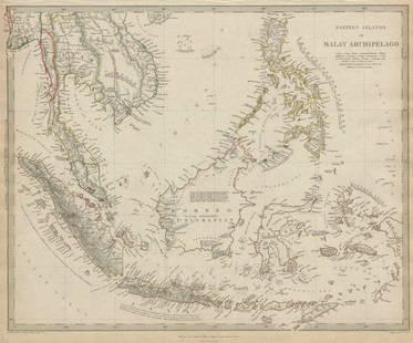
Sold2020MALAY ARCHIPELAGO Indonesia Malaysia PhilippinesTITLE/CONTENT OF MAP: 'EASTERN ISLANDS OR THE MALAY ARCHIPELAGO. Sumatra, Java, Borneo, etc' The top image on the right hand side shows the entire map. To view a close up of the map showing the levelSee Sold Price
Sold2020MALAY ARCHIPELAGO Indonesia Malaysia PhilippinesTITLE/CONTENT OF MAP: 'EASTERN ISLANDS OR THE MALAY ARCHIPELAGO. Sumatra, Java, Borneo, etc' The top image on the right hand side shows the entire map. To view a close up of the map showing the levelSee Sold Price
Sold2015Early Map of Napoli ItalyRegno di Napoli / Fabio di Gio Antonio Magini. 1620 or earlier. on Chain-lined period paper. Center fold. Pencil Writing in the margins. Plate impression visible. Framed under glass. Not inspected outSee Sold Price
6 days LeftHolabird Western Americana CollectionsSanitary & Topographical "Viele Map" of Manhattan 1865 [182838]$750
BonhamsAFRICA MUNSTER (SEBASTIAN) Africa Lybia Morenlandt mit allen königreichen so zu unsern zeit...£300
6 days LeftHolabird Western Americana CollectionsMap of Mare Island Straits California by Bache, 1851 [179999]$50
5 days LeftJasper52Partie Occidentale de l’Afrique. West Africa coast Canary islands BONNE 1788 map$15
Jun 08Trillium Antique Prints & Rare BooksSanson - Map of California as an Island, Mexico (Audience de Guadalajara)$75
5 days LeftFreeman's | HindmanSTEVENSON, Robert Louis (1850-1894). Treasure Island. London, Paris & New York: Cassell & Company,$1,500
Jun 08Early American History Auctionsc 1730 Hand-Colored Colonial Era Map of the Americas, California shown as an Island, Matted + Framed$500(1 bid)


![World: Ptolemy, pub. 1562 - Map of the Ancient World: This early map engraving is Joseph Moleti (Giseppi Moleti [Moletius])'s edition of Claudius Ptolemaeus (Ptolemy)'s Geographia. This is the first Moleti Latin edition of the work and was published by V](https://p1.liveauctioneers.com/6581/307341/164260812_1_x.jpg?height=310&quality=70&version=1698409008)
![Ptolemy, pub. 1562 - Map of Italy: This early map engraving is Joseph Moleti (Giseppi Moleti [Moletius])'s edition of Claudius Ptolemaeus (Ptolemy)'s Geographia. This is the first Moleti Latin edition of the work and was published by V](https://p1.liveauctioneers.com/6581/306422/163689119_1_x.jpg?height=310&quality=70&version=1697805653)
![Ptolemy, pub. 1562 - Map of Sardinia & Sicily: This early map engraving is Joseph Moleti (Giseppi Moleti [Moletius])'s edition of Claudius Ptolemaeus (Ptolemy)'s Geographia. This is the first Moleti Latin edition of the work and was published by V](https://p1.liveauctioneers.com/6581/306422/163689120_1_x.jpg?height=310&quality=70&version=1697805653)
![Ptolemy, pub. 1562 - Map of Sardinia & Sicily: This early map engraving is Joseph Moleti (Giseppi Moleti [Moletius])'s edition of Claudius Ptolemaeus (Ptolemy)'s Geographia. This is the first Moleti Latin edition of the work and was published by V](https://p1.liveauctioneers.com/6581/310450/166144993_1_x.jpg?height=310&quality=70&version=1700658590)


![Ptolemy / Waldseemuller Map of Sri Lanka or Taprobana, 1513 or 1520: PTOLEMY, Claudius (2nd Century) & WALDSEEMULLER, Martin (1470-1520). [Sri Lanka or Taprobana] Duodecima Asiae Tabula. Woodcut Map with original hand color. Strasbourg: Schott, 1513 or 1520. 17 1/2" x](https://p1.liveauctioneers.com/1968/250616/130196500_1_x.jpg?height=310&quality=70&version=1654190895)


![Sanitary & Topographical "Viele Map" of Manhattan 1865 [182838] (1 of 3)](https://p1.liveauctioneers.com/2699/331495/178785766_1_x.jpg?height=282&quality=70&version=1717094933)


![Map of Mare Island Straits California by Bache, 1851 [179999] (1 of 1)](https://p1.liveauctioneers.com/2699/331495/178785781_1_x.jpg?height=282&quality=70&version=1717094933)


![[MAP]. ORTELIUS, Abraham. Aevi Veteris, Typus Geographicus. 1601. (1 of 3)](https://p1.liveauctioneers.com/197/329395/177650532_1_x.jpg?height=282&quality=70&version=1715364962)

